
Dirt Roads

Moose River Recreation Area: Home of the "Black Fly Challenge"

Location: Between Inlet & Indian Lake

Distance: Over 40 miles of gravel roads & 30 miles of marked trails

Difficulty: Beginner / Intermediate with some expert

Description:This is mountain biker heaven. Going into 'The Plains' from the Limekiln Gate is a rolling gravel road with hills from moderate to steep grades.If you don't want to tackle the 'big hill' between the gate and Red River you can drive in, park and ride. There are about 100 free campsites spread through the area.

Uncas Road

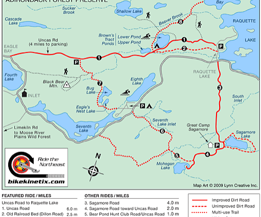
Location: Inlet to Raquette Lake

Distance: 10 miles one way

Difficulty: Beginner

Description: This is a fast, fun ride! Uncas Road follows the the path of the old Raquette Lake Railroad from Eagle Bay to Brown Tract Ponds. At the upper pond, directly across from the Sucker Brook Trail, is a right turn that cuts from the road over to the snowmobile trail, which is flat right into Raquette Lake village.

If you stay on the road past the DEC Campground you will have to ride over Fox Mountain.

BikeKinetix


Sagamore Road

Location: Raquette Lake
Distance: 4 miles one way
Difficulity: Intermediate
Description: Rolling dirt road


Endion Road

Location: Intersects with Route 30, North of Long Lake on the left side of the highway just north of the Kickerville Road
Distance: 2 miles
Difficulty: Beginner
Description: The Endion Road is a winding paved road. There are no major hills on this road and traffic is relatively light. In the fall it is an exceptionally pleasing ride as the trees actually provide a partial canopy in places.


Kickerville Road

Location: Long Lake
Distance: 3 miles
Difficulty: Beginner
Description: This is another paved town highway, which provides a very easy ride with only very minor changes in elevation and provides a very colorful ride in the fall.


North Point Road

Location: 3.2 mi. southwest of the Long Lake Town Hall just off Route 30.
Distance: 11 miles one way
Difficulty: Beginner
Description: On your way, don't miss Buttermilk Falls. Camping is allowed on State land bordering this road. Forked Lake State Campsite is on the road to the right off North Point Rd.


Buttermilk Falls

Location: The entrance to the falls is on the right side of the North Point Road, 2.1 miles from the intersection with Route 30.  
Distance:
Difficulty:
Description: A short walk to the falls is fine for all ages. There is a 2.5-mile canoe carry around the falls.

Forked Lake Road

Location: North Point Rd. Long Lake
Distance:
Difficulty: Beginner
Description: The Forked Lake Road is a nice place to ride. This area is great for all ages and provides much opportunity to see wildlife without having to go on rough trails.


Sabattis Road

Location: 6 mi. northwest from the Long Lake Town Hall on Rte. 30
Distance: 12 miles
Difficulty: Beginner
Description: You can ride to the end of the road where there are abandoned railroad tracks, which were part of the Adirondack Railway that ran from Utica to Lake Placid. For a shorter ride you can take the part of Sabattis Rd. that loops back to Rte. 30. There is no bike trail here. You must use the highway.


Santanoni Great Camp

Location: Newcomb Lake Road. Access to this trail is on the North Side of Rout 28N less than a mile east of the High Peaks Scenic outlook in Newcomb.
Distance: 4.5 miles one way
Difficulty: Beginner
Description: This trail is a gently rolling dirt road closed to all motorized vehicles except DEC and provides access to Great Camp Santanoni. This trail is an excellent choice for a family outing as the road is very well maintained. There is a superb view of the high peak area at the end of your ride.